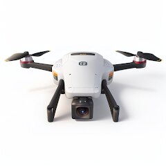
Drone App: Forecast for UAV

1M+
Installs
Go Dreams
Developer
-
Finance
Category
-
Everyone
Content Rating
-
https://gardenofdreams.games/privacy-policy-3
Privacy Policy
editor reviews
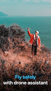
For drone enthusiasts and professionals, flying a UAV often feels like a delicate dance with the sky. You check the weather, but standard forecasts don't account for the specific conditions at 50, 100, or 200 meters up. That's where Drone App: Forecast for UAV by Go Dreams steps in, and honestly, it has become my go-to tool for planning flights. What sets this app apart is its laser focus on drone-specific meteorological data—things like wind speed at various altitudes, thermal activity, and solar storms that can mess with your GPS. I chose this app because it cuts through the noise of general weather apps, giving me straight-to-the-point information that directly impacts my drone's performance and safety. The interface is clean, intuitive, and packed with data that even a beginner can interpret after a short time using it. 😎⚡🌥️ From my experience, this app has saved me from potential crashes more times than I can count, especially when flying in unpredictable coastal areas or gusty city environments. It's not just about avoiding rain; it's about understanding the invisible forces that push your drone around up there. The development team has clearly done their homework, and it shows in the app's accuracy and reliability over the months I've used it. 🚁💨🌤️
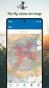
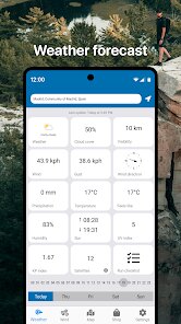
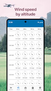
Exploring the app deeper, I found that its core strength lies in its ability to display dynamic wind layers and storm alerts specifically tailored for UAV operation. Unlike generic weather apps that lump all data together, this one breaks it down by altitude, helping you decide if it's safe to fly at 10 meters or if you need to stay lower to avoid turbulence. I remember a particular session where the app pinged me about an approaching microburst—a phenomenon most standard forecasts ignore. That alert alone prevented what could have been a costly disaster for my equipment. The real-time updates are another gem; they refresh frequently enough to catch sudden changes, which is crucial for long-duration shoots or mapping missions. 🛰️💡🔄 You get a colored map overlaid with wind vectors, cloud coverage, and even Kp index data for magnetic interference, which is a blessing for photographers using GPS-dependent models like the DJI Mavic 3. It's practical, not just theoretical, and that's exactly what you need when you're holding a remote controller with a thousand-dollar drone in the air. 🎨📍📸
If you're tired of guessing whether the wind will pick up after lunch or if the clouds will clear before sunset, this app is your new best friend. It bridges the gap between amateur weather checking and professional-grade flight planning, putting all the essential data at your fingertips. I genuinely believe that every drone pilot—from hobbyists flying for fun to professionals doing cinematic work—should have this app on their phone. It's not perfect, but it's far better than anything else I've tried in this niche. So, go ahead and download Drone App: Forecast for UAV from the App Store now. Your drone will thank you, and you'll sleep better knowing you made the smart choice for your pre-flight checks. ✈️📲💥 Trust me, once you start using it, you won't look back at those half-baked weather widgets again. Get it today and experience the difference it makes in your flying sessions! 🚀✅🎯
features
- 🚁 Altitude-Specific Wind Data: This feature provides wind speed and direction broken down by specific flight altitudes, such as 50m, 100m, and 200m, allowing you to avoid dangerous gusts that only exist at certain heights. I've found this invaluable for urban flying where wind patterns shift dramatically between building tops and street level. 🌬️📏
- ⚡ Real-Time Storm Alerts: The app sends immediate notifications about approaching thunderstorms, microbursts, and other severe weather events that could impact your drone's safety. It's like having a personal meteorologist in your pocket, always watching the radar for you. ⚠️🌧️
- 🌐 GPS Interference Index: This tool uses the Kp index to forecast solar and magnetic activity that can disrupt your drone's satellite connection. When the index is high, you'll know to delay your mission to avoid losing GPS lock mid-flight. 🛰️🧲
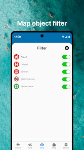
- 🧭 Dynamic Overlay Maps: The app presents a visual map with color-coded wind vectors, cloud cover, and visibility layers, making it easy to scan for ideal flying zones at a glance. I use this to pick out safe corridors for navigation during complex shoots. 🗺️🎨
- 📡 Historical Flight Logs: It records your past flights along with the weather conditions at that time, helping you learn from your experiences and plan better routes based on previous successes or failures. 📋🕐
pros
- 🎯 Accuracy and Relevance: The data is incredibly reliable for drone operations, with wind speed and storm predictions that match real-world conditions better than any general weather app I have used. This reduces guesswork and boosts confidence before takeoff. 👍📉
- ⚡ User-Friendly Interface: The layout is straightforward and intuitive, with big icons and clear labels that don't overwhelm you with technical jargon. Even someone new to flying can quickly understand the information and make safe decisions without stress. 🧩😊
- 📱 Regular Updates and Support: Go Dreams pushes frequent updates that fix bugs, add new features, and improve accuracy over time. Their customer support is responsive and genuinely helpful when you run into issues or have suggestions. 🔄💬
cons
- 💸 Premium Subscription Cost: To unlock all features, you need to pay for a recurring subscription, which can feel expensive for occasional flyers who only want basic wind checks. There is no one-time purchase option, which makes long-term use a financial commitment. 💵😕
- 📶 Connectivity Dependence: The app relies heavily on a stable internet connection to fetch real-time data and map overlays. In remote areas with poor signal, some core functions become sluggish or unavailable, which is a serious drawback for wilderness pilots. 📵🌲
- 📊 Battery Drain and Performance: Running the app with live maps and alerts can drain your phone's battery quickly, especially on older devices. Additionally, it sometimes lags during heavy data loading, causing frustration when you need quick answers before a flight. 🔋🐌
Articles
![]()
How to Get Robux Safely Without Scams
![]()
How to Download Older Versions of Android Apps
![]()
How to Download Games on Google Play for the First Time
![]()
What Is an APK File for Android? Everything You Need to Know
![]()
Do Free Robux Generators Work?
![]()
Robux Pricing Guide (2026 Update): How Much Robux Really Costs
![]()
How to Avoid Scams in Roblox
![]()
Rarest Pets in Adopt Me! (2026 Update)
![]()
How to Trade Safely in Adopt Me! (So You Don't Lose Everything)
![]()
Secret Tricks Nobody Tells You in 'Steal a Brainrot'
![]()
Beginner Guide: Don't Lose Your Brainrot
![]()
How to Steal in 'Steal a Brainrot' Without Getting Caught (Or at Least Not Instantly)
![]()
Is Brookhaven RP Worth Playing? It Depends on What You’re Looking For
![]()
Why Blox Fruits Is So Popular? Here’s Why Everyone Keeps Playing It
![]()
Best Roblox Obby Games for Beginners (2026): Learn the Game Without Hitting a Wall
![]()
Top 10 Roblox Horror Games (2026): The Scariest Experiences You Can't Miss


Hot Apps
-
![]()
Affirm: Buy now, pay over time
Affirm, Inc4.7

-
![]()
ChatGPT
OpenAI4.7 -
![]()
Google Chat
Google LLC4.4 -
![]()
Yuka - Food & cosmetic scan
Yuka App4.7 -
![]()
SiriusXM: Music, Sports & News
SiriusXM4.6 -
![]()
Duolingo: Language & Chess
Duolingo4.7 -
![]()
Google Home
Google LLC4.2 -
![]()
Instagram
Instagram4.3 -
![]()
WhatsApp Messenger
WhatsApp LLC4.2 -
![]()
ChatBot - AI Chat
X PhotoKit4.5 -
![]()
DoorDash - Food Delivery
DoorDash4.6 -
![]()
Microsoft Teams
Microsoft Corporation4.6 -
![]()
Direct Express®
i2c Inc.4.3 -
![]()
Geeni
Merkury Innovations4.6 -
![]()
Google Maps
Google LLC4.2 -
![]()
Snapmint: Buy Now, Pay in EMIs
Snapmint4.5 -
![]()
Pandora - Music & Podcasts
Pandora4.1 -
![]()
Chai: Chat AI Platform
Chai Research Corp.4.4 -
![]()
Uber Eats: Food Delivery
Uber Technologies, Inc.4.3 -
![]()
Venmo
PayPal, Inc.4.2 -
![]()
Perplexity - Ask Anything
PerplexityAI4.7 -
![]()
Google Chrome: Fast & Secure
Google LLC4.1 -
![]()
Bolt: Request a Ride
Bolt Technology4.8 -
![]()
OfferUp: Buy. Sell. Letgo.
OfferUp Inc.4.4 -
![]()
Uber - Request a ride
Uber Technologies, Inc.4.6 -
![]()
Ticketmaster-Buy, Sell Tickets
Ticketmaster L.L.C.3 -
![]()
Snapchat
Snap Inc4.1 -
![]()
Wise: International Transfers
Wise Payments Ltd.4.7 -
![]()
Microsoft Copilot
Microsoft Corporation4.8 -
![]()
YouTube
Google LLC4.1


Disclaimer
1.Appinfocenter does not represent any developer, nor is it the developer of any App or game.
2.Appinfocenter provide custom reviews of Apps written by our own reviewers, and detailed information of these Apps, such as developer contacts, ratings and screenshots.
3. All trademarks, registered trademarks, product names and company names or logos appearing on the site are the property of their respective owners.
4.Appinfocenter abides by the federal Digital Millennium Copyright Act (DMCA) by responding to notices of alleged infringement that complies with the DMCA and other applicable laws.
5.If you are the owner or copyright representative and want to delete your information, please contact us [email protected].
6.All the information on this website is strictly observed all the terms and conditions of Google Ads Advertising policies and Google Unwanted Software policy.
7.Appinfocenter.com is an independent, information-only website which is 100% free to all the users.